Photo Geographic Trajectory Extraction Research
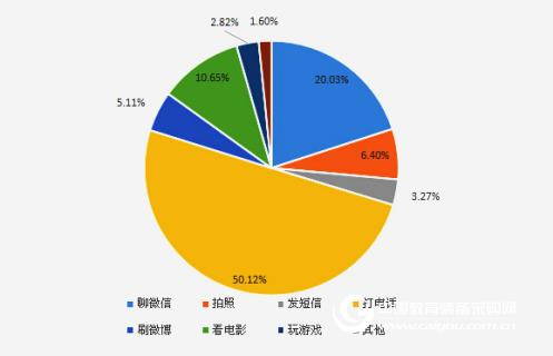
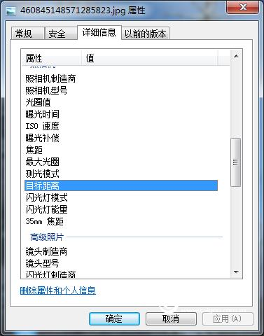
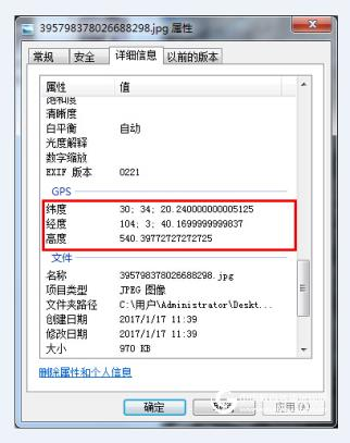
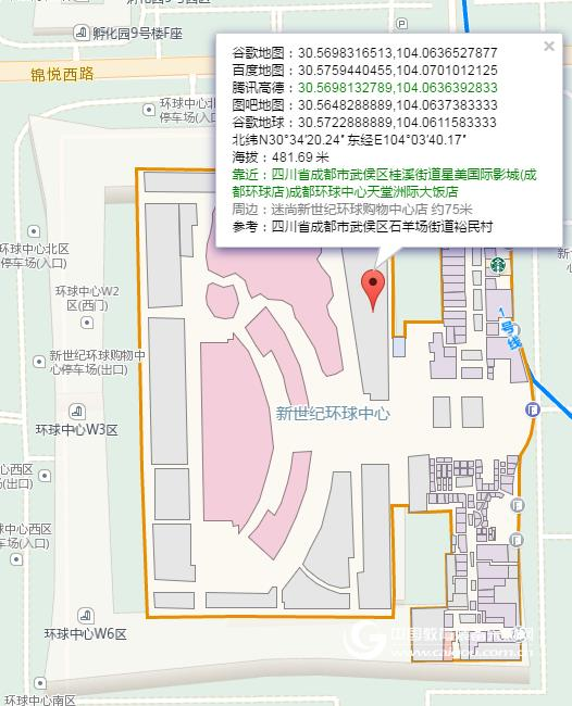
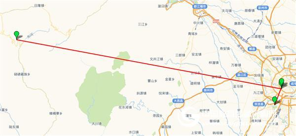
Editor's Note: In the field of mobile electronic data forensics, in addition to important information such as mobile phone text messages, address books, and call records, mobile phone photos are also an important extract. Mobile phone photos may contain important data such as shooting time, shooting distance, shooting latitude and longitude. If you associate these information, you can form a user's track of trajectory, which helps to detect and collect evidence. In this issue, researchers at the Key Laboratory of Data Recovery in Sichuan Province will introduce the information contained in the photos of mobile phones and how to extract the geographic trajectories of mobile phones. First, the background introduction With the increasing popularity of smartphones, taking pictures with mobile phones has become more widespread. According to the "2016 Mobile Phone Usage Habits Survey Report", the use of mobile phone camera functions ranked in the fourth place in mainstream mobile phone use after making calls, chatting on WeChat, watching movies, as shown in Figure 1. When taking a mobile phone photo, if the mobile phone has the GPS location service function enabled, other users can view the user's shooting location and other information through the mobile phone photo. figure 1 Second, extract the meaning of the geographical trajectory For mobile electronic data forensics, all the photos in the smartphone are extracted (including the deleted photos), and the information such as creation time, last modification time, latitude and longitude in the extracted photos are sorted by time, and the corresponding order is Marked on the map, you can clearly know the user's geographic trajectory, which is important for the detection or forensics of the case. Third, the information contained in the photo For photos in the phone, in addition to the attributes such as image ID, size, height, width, resolution, etc., the camera's own properties such as camera manufacturer, model, aperture value, exposure time, etc. can be stored. For mobile electronic data forensics, mobile phone photos may also store some more important data: 1. Shooting target distance There are certain distances for taking pictures. For example, the distance of self-timer is usually about 1 meter, and the distance of sneak shot is usually more than 10 meters. Of course, we can also find the shooting distance information from the phone photo properties, as shown in Figure 2. By comparing the shooting target distance with the shooting target, the geographical range of the user can be obtained. figure 2 2. Photo latitude and longitude Latitude and longitude are used frequently on the map, but now mobile photos can also store latitude and longitude information, as shown in Figure 3. image 3 Using the latitude and longitude information data in Figure 3, after a certain method of conversion, the coordinates of the GPS latitude and longitude are obtained as latitude: 30.5722888888889, longitude: 104.061158333333. According to the latitude and longitude query, the coordinate address is: Chengdu Intercontinental Hotel, Chengdu Global Center, Guixi International Cinema (Chengdu Global Store), Wuxi District, Chengdu, Sichuan Province, as shown in Figure 4. Figure 4 From this, we can find out the specific location of the photo shoot. Fourth, photo geographic track extraction A mobile phone usually contains a lot of photos. We can use the efficiency source MTF mobile phone visual tracking and forensics system to extract all the photos in the mobile phone (the deleted photos can be deeply restored). The software can automatically associate the important information such as creation time, last modification time, latitude and longitude in the extracted photos in chronological order, and finally mark the latitude and longitude on the map, as shown in Fig. 5. In this way, the forensic personnel can quickly understand the relevant geographic trajectory information of the mobile phone user. Figure 5 5. What photos have no latitude and longitude? 1. If the GPS positioning of the mobile phone is not turned on, the photos taken by the mobile phone will not store the latitude and longitude information, which is a self-privacy protection measure. 2. Photos uploaded to QQ space or WeChat friends circle are also latitude and longitude, because software developers will erase this information for user privacy. Conclusion: In addition to directly responding to the subject, the mobile phone photo also contains important information such as shooting time, shooting distance, and shooting latitude and longitude. Utilizing the efficiency source MTF mobile phone visualization and forensics system can realize complete extraction of mobile phone photos and correlate relevant information to form an intuitive geographic trajectory map, which can provide important clues for case detection or forensics and improve work efficiency. outdoor pet house,indoor pet house,small pet house,pet bed house,Comfortable pet house AUTRENDS INTERNATIONAL LIMITED , https://www.petspetstoys.com